|
Zeitblick
/ Das Online-Magazin der HillAc -
10. März 2012 - Nr. 42
|
City,
My City |
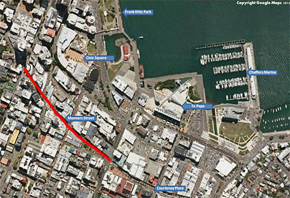
A Link in the Golden Mile A succession of Wellington streets – Lambton Quay, Willis Street, Manners Street and Courtenay Place traverse central Wellington city from north-west to south-east. Together these streets make up what is locally known as the "Golden Mile", a continuous shopping precinct stretching from Parliament Buildings in Thorndon, south and east to Courtenay Place in Te Aro. The districts of Thorndon and Te Aro are two historic Wellington inner-city suburbs, existing since the foundation of the city in 1840 and once known as the Thorndon Ward and Te Aro Ward. Joining these two suburbs is one of the original east-west thoroughfares of Wellington City, a road named Manners Street. As was common during the early planning and development phase of the city, many streets and landmarks were named for members of the New Zealand Company or their associates and members of their families. Lambton Quay, Willis Street, Somes Island, Point Jerningham and Point Halswell, for instance, were all named for early Wellington identities while two of the highest peaks in the surrounding landscape were named for those recognised at eht pinnacle of the British Empire at that time - Queen Victoria (Mount Victoria) and her consort Prince Albert (Mount Albert). In this same vein, Manners Street was named for a director of the New Zealand Company, Frederick James Tollemache, whose father was Sir William Manners otherwise known as Sir William Manners Tollemache, a surname he adopted from his mother, Louisa Tollemache, 7th Countess of Dysart.
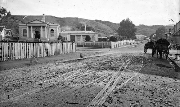
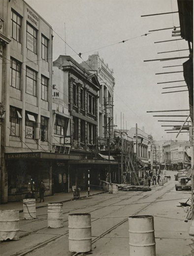
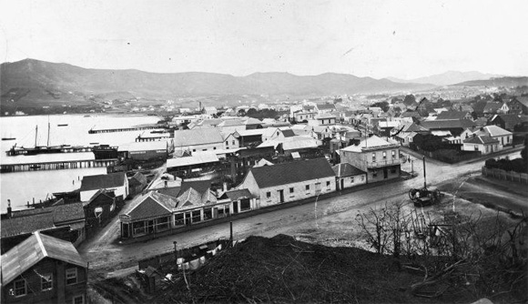
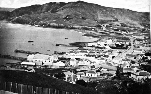
In those early days, before reclamation pushed the shoreline further out into the harbour, Manners Street was only a few steps from the water’s edge, becoming an important thoroughfare to the several wharves that lined the Te Aro waterfront. The contours of Manners Street, originally matching the shoreline, remain as they have for the past 170 years and the location and names of many of its original side-roads have remained unchanged. Indeed many of these side-roads are a history lesson in themselves. For instance St Hill Street is named for Henry St Hill, an early pioneer by the ship Adelaide; Lombard and Cornhill Streets are named for London streets bearing the same name; Cuba Street is named, of course, for the New Zealand Company exploration ship Cuba; Luke's Lane is named for Captain Luke the owner of a small engineering firm (S. Luke & Sons) existing on the site and Taranaki Street, named for what was once known as Taranaki Pa (since known as Te Aro Pa) and which once stood on that spot near the original coastline. The Manners Street roadway today is narrower, its footpaths are broader and the buildings, of course, have changed but some are remembered in the names of present-day locations, names which were bequeathed to them by the structures once standing there. Perrett's Corner, now the location of the Perretts Corner Cafe, was once the site of a chemist shop owned by Claude H Perrett and his brother Edwin. Many of us with long memories still refer to this location as Perrett's Corner, more perhaps as a geographical location than for its historical significance although, come to think about it, perhaps for both reasons. On the opposite side of the road we have The Duke, or Dukes Arcade as it is popularly known, again named for a location with historical significance. In 1870 this corner was the site of the of the Duke of Edinburgh Hotel which lends its name to the present-day site after the building was demolished 100 years later in the early 1970's. Next door to the hotel was the Britannia Theatre, built in 1913, and renamed Roxy in 1935. The Roxy cinema was the location of the first continuous-screened movies in Wellington between 1935 and 1975. Other shops and outlets have been and gone over the years, swallowed up in the panoply of change that is the progress of history. The Criterion Cafe, The Lamphouse, The Princess Theatre, The Peoples Picture Palace and many more shops, restaurants, cafes, cinemas, beauty salons, theatres and pubs have graced this section of Wellington's Golden Mile.
In those early days, before reclamation pushed the shoreline further out into the harbour, Manners Street was only a few steps from the water’s edge, becoming an important thoroughfare to the several wharves that lined the Te Aro waterfront. The contours of Manners Street, originally matching the shoreline, remain as they have for the past 170 years and the location and names of many of its original side-roads have remained unchanged. Indeed many of these side-roads are a history lesson in themselves. For instance St Hill Street is named for Henry St Hill, an early pioneer by the ship Adelaide; Lombard and Cornhill Streets are named for London streets bearing the same name; Cuba Street is named, of course, for the New Zealand Company exploration ship Cuba; Luke's Lane is named for Captain Luke the owner of a small engineering firm (S. Luke & Sons) existing on the site and Taranaki Street, named for what was once known as Taranaki Pa (since known as Te Aro Pa) and which once stood on that spot near the original coastline. The Manners Street roadway today is narrower, its footpaths are broader and the buildings, of course, have changed but some are remembered in the names of present-day locations, names which were bequeathed to them by the structures once standing there. Perrett's Corner, now the location of the Perretts Corner Cafe, was once the site of a chemist shop owned by Claude H Perrett and his brother Edwin. Many of us with long memories still refer to this location as Perrett's Corner, more perhaps as a geographical location than for its historical significance although, come to think about it, perhaps for both reasons. On the opposite side of the road we have The Duke, or Dukes Arcade as it is popularly known, again named for a location with historical significance. In 1870 this corner was the site of the of the Duke of Edinburgh Hotel which lends its name to the present-day site after the building was demolished 100 years later in the early 1970's. Next door to the hotel was the Britannia Theatre, built in 1913, and renamed Roxy in 1935. The Roxy cinema was the location of the first continuous-screened movies in Wellington between 1935 and 1975. Other shops and outlets have been and gone over the years, swallowed up in the panoply of change that is the progress of history. The Criterion Cafe, The Lamphouse, The Princess Theatre, The Peoples Picture Palace and many more shops, restaurants, cafes, cinemas, beauty salons, theatres and pubs have graced this section of Wellington's Golden Mile.
In Manners Street and throughout some of the surrounding streets of Te Aro an infamous affair took place on the evening of April 3rd 1943, an affair which has gone down in Wellington folklore and in the history of the 2nd Division, United States Marines. The "Battle of Manners Street", as it has become known, was a major brawl which took place between soldiers of the US Marines, stationed in Wellington, and soldiers of the New Zealand Army, many of whom had recently returned from battle in Europe or North Africa. The Allied Services Club was located in Manners Street on the site of the present day Post Office opposite McDonalds. Catering to all servicemen in Wellington at the time their clientele was always a mixture of American Marines, US Army servicemen and New Zealand soldiers and merchant seamen, perhaps a volatile mix at the best of times as many Kiwi soldiers believed their American allies to be, in the tradition of the time, "oversexed, overpaid, and over here". While no single reason has ever been given for the origin of the altercation, many explanations have been offered and doubtless there was blame and insult on both sides. Nevertheless the fight began and soon spilled out onto Manners Street and rapidly spread to nearby Cuba Street, Willis Street and Lambton Quay. The Marines, as was their tradition, removed their belts and used them with their solid buckles as a weapon gaining, no doubt, some measure of advantage over the Kiwis. Continuing for about four hours the "battle" eventually wound up due to a combination of military police, fatigue and concern by the Americans that they would miss the last train to their camp at Paekakariki. Reports of deaths from the fight are false and many aspects were greatly exaggerated although contemporary media reports of the incident were censored due to the war. In speaking with my Mother about her memories of the events of that time, she largely dismissed the melodrama saying instead that there were "Some bloody noses and bruises". Mum had a way of getting to the nub of the matter with things.
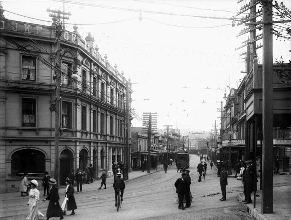
From harbour-side road to inner-city artery Manners Street appears to have undergone significant change over the years. Little, however, about the original route of the road has changed as it still follows the same route it has always done. From Willis Street to Courtenay Place the course of Manners Street was mapped, as many streets within the original city were, by the contours of coastline, hillside, swamp and rolling plain. Side roads have been added and removed, but not very often; pedestrian malls and footpaths have been created, widened, built up and demolished all, it would seem, at the whim of Wellington’s city fathers; the direction of vehicular traffic has been changed from two-way to one-way, briefly during the lifetime of Manners [pedestrian] Mall, to no-way and now back to two-way. For the past 170 years pedestrians, horses, horse-drawn carts, omnibuses, tramcars, buses, trucks, motorbikes and motorcars [not to mention pedestrians] have travelled both eastwards and westwards along Manners Street, ensuring its place is preserved as an important thoroughfare for the commerce and commercial communication of the city. A glimpse of the historic photographs will show that it is the buildings lining this street which have imposed the greatest change to its surroundings. Wooden structures have disappeared to be replaced by shiny glass & steel, small buildings became much larger ones and commercial structures gradually replaced residential ones. Manners Street remains, however, as it has always done.
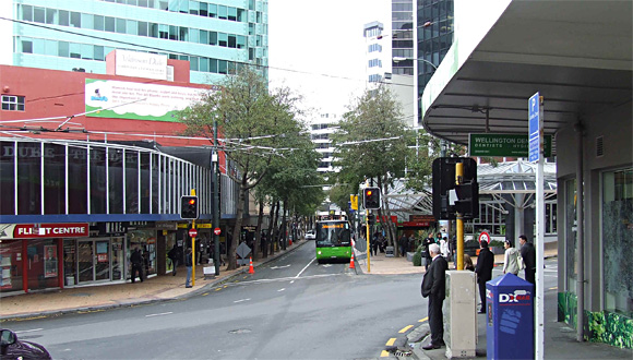
In 2010 Manners Street (including Manners Mall) was “modified” by the local council to transform it from a one way bus and motor vehicle thoroughfare to a two way bus-only route incorporating it, they believed, more fully into the Golden Mile. Unfortunately the change-over resulted in at least 7 pedestrian vs bus accidents and, in the author’s memory, one death when pedestrians, familiar as they were with previous one-way traffic, forgot to look both ways before crossing the road. Such misunderstandings and accidents have thankfully ceased but our councillors are now planning another route change in which they will remove bus traffic from Manners Street and the Golden Mile all together and re-route it outside the limits of the CBD. What price progress?
© Peter Wells, Wellington, New Zealand |